Course on emagrams: understanding, reading, deciphering ...
Wiki page: http://fr.wikipedia.org/wiki/%C3%89magramme
Course on emagrams (free flight, ulm, gliders ...)
-
Christophe
- Moderator

- posts: 79359
- Registration: 10/02/03, 14:06
- Location: Greenhouse planet
- x 11060
To be stored in the countless time charts, where there was no programmable calculator and computer.
Basic thermodynamics !!
http://fr.wikipedia.org/wiki/Diagramme_de_phase
http://en.wikipedia.org/wiki/Thermodynamic_diagrams
http://en.wikipedia.org/wiki/Phase_diagram
http://fr.wikipedia.org/wiki/%C3%89nerg ... disponible
http://fr.wikipedia.org/wiki/T%C3%A9phigramme
http://fr.wikipedia.org/wiki/Atmosph%C3%A8re_terrestre
etc ...
Very good to make a vortex tower with a cyclone in it on a stretch of hot water, by not walking there in ULM .
http://fr.wikipedia.org/wiki/%C3%89nerg ... disponible
Basic thermodynamics !!
http://fr.wikipedia.org/wiki/Diagramme_de_phase
http://en.wikipedia.org/wiki/Thermodynamic_diagrams
http://en.wikipedia.org/wiki/Phase_diagram
http://fr.wikipedia.org/wiki/%C3%89nerg ... disponible
http://fr.wikipedia.org/wiki/T%C3%A9phigramme
http://fr.wikipedia.org/wiki/Atmosph%C3%A8re_terrestre
etc ...
Very good to make a vortex tower with a cyclone in it on a stretch of hot water, by not walking there in ULM .
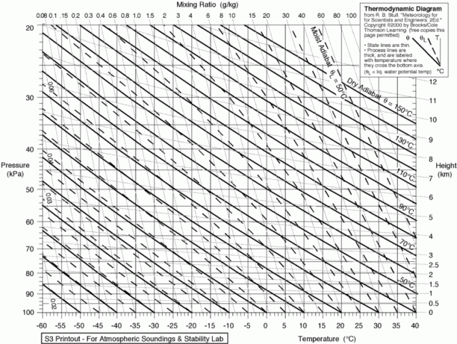
The emagram is one of the four thermodynamic diagrams used to analyze the thermal structure of the atmosphere. It is used to point the temperature and the dew point coming from an aerological survey by radiosondes, from an airplane or extrapolated by satellite. The axes of the emagram are those of temperature (T) and of the logarithm of the pressure (P) in a semi-logarithmic coordinate system. These axes are perpendicular in the original diagram but the most common version is the one whose temperature axis is 45 degrees to the right, the latter is called SkewT in the United States and emagram 761 in France1,2.
The anagram was developed in 1884 by Heinrich Hertz. In its original form, it is mainly used in Europe. By pointing the temperature and the dew point on the emagram, we can calculate the stability of the air and the potential energy of convection available (EPCD), known as CAPE in English. Winds at different pressure levels are often added in the margin as barbules
The tephigram was developed by Napier Shaw in 1915. It is used in Great Britain, Canada and other countries. Its main characteristic is that the area between two temperature curves plotted on a tephigram is equal to the energy difference between the two curves. Indeed, the energy in the Carnot cycle is:
E = - C_p \ oint T d ln \ theta = - C_p \ Delta T \ Delta \ phi
or :
T = Temperature
\ theta = Temperature of the plot of air at pressure P which would have been reduced to the pressure of 100 kPa according to a dry adiabatic.
Thus, one can easily calculate the energy of a convective particle with respect to the environment, what is called the potential energy of available convection (EPCD, CAPE in English). The example on the right shows the energy in yellow between a particle warmed to 25 ° C (curve in red) compared to the environment (black line). The gray line gives the dew point of the environment and the blue one the temperature of the wet thermometer.
http://fr.wikipedia.org/wiki/%C3%89nerg ... disponible
One of the parameters used to estimate the potential for violence in a thunderstorm is the EPCD. Indeed, the stronger the updraft, the more it will be able to withstand large hailstones, or a large mass of precipitation. In addition, if the rising current has a certain rotation, there is a good possibility of tornado development. However, the EPCD is not the only factor since wind shear with altitude is also crucial.
Here are typical values for EPCD1:
0 to 1000 J / kg: marginally unstable giving showers or ordinary thunderstorms;
1000 to 2500 J / kg: moderately unstable giving thunderstorms which can be violent;
2500 to 3500 J / kg: very unstable giving severe thunderstorms;
3500 J / kg or more: extremely unstable and very favorable to generalized violent storms.
0 x
Re: Course on emagrams (free flight, ulm, gliders ...)
Very interesting.Christophe wrote:Course on emagrams: understanding, reading, deciphering ...
To whom do we owe this excellent presentation.
It reminds me of the popular presentations of our dear Michel Kieffer that I haven't read for a while ...
0 x
-
Christophe
- Moderator
- posts: 79359
- Registration: 10/02/03, 14:06
- Location: Greenhouse planet
- x 11060
Ah yes Michel misses us all lol!
This comes from an info session organized by my paragliding club and led by a certain JP Bihin
I did not attend this session and I have not yet understood everything at .pdf ...
Here is an emagram in real time: http://meteociel.fr/modeles/sondage2.ph ... 580&y1=350
http://meteociel.fr/modeles/sondagegfs/ ... 0_15_0.png
I have not yet found how to change the coordinates ...
This comes from an info session organized by my paragliding club and led by a certain JP Bihin
Discovery session of emagrams.
What is the use of these graphics for the paraglider?
They allow you to predict at a glance if there will be instability, what will be the altitude of the ceilings and the amount of cloud cover.
They are a valuable complement to your weather forecast sites.
Where are they found?
On the Internet, you can find everything but you have to know what to choose ...
During the training, I will offer you a list of the most interesting sites.
Will it be difficult?
Three hours of training, for those who are no longer used to going to school, it's always a little tiring. But there will be no great mathematical or physical reasoning here, no calculations, no complicated formulas. We will work mainly on the visual aspects - just the shape of the graph already speaks - and the understanding of the phenomena. You can count on an alternation of lectures and practical exercises.
See you soon!
Jean-Paul Bihin
I did not attend this session and I have not yet understood everything at .pdf ...
Here is an emagram in real time: http://meteociel.fr/modeles/sondage2.ph ... 580&y1=350
http://meteociel.fr/modeles/sondagegfs/ ... 0_15_0.png
I have not yet found how to change the coordinates ...
0 x
Do a image search or an text search - Netiquette of forum
Much clearer, with the various links and the physics on wikipedia, which gives the demonstrations and formulas, in my opinion essential, to really understand, with the basic thermodynamics behind, instead of lesson of things.
A cloud, a thunderstorm or a tornado, it's a Carnot machine based on that.
http://fr.wikipedia.org/wiki/%C3%89nerg ... disponible
http://fr.wikipedia.org/wiki/Circulatio ... C3%A9rique
A cloud, a thunderstorm or a tornado, it's a Carnot machine based on that.
http://fr.wikipedia.org/wiki/%C3%89nerg ... disponible
http://fr.wikipedia.org/wiki/Circulatio ... C3%A9rique
0 x
They mention wind shear:
http://fr.wikipedia.org/wiki/Cisaillement_du_vent
http://fr.wikipedia.org/wiki/Cisaillement_du_vent
Shear winds are known to disturb aircraft, especially during takeoff and landing by disturbing the relative wind speed or by producing turbulence.
They are a key factor governing the intensity of severe thunderstorms (supercell thunderstorms) and tornadic thunderstorms.
They inhibit the development of tropical cyclones.
Shear winds are very dangerous for aviation when the aircraft is close to the ground at low speed, that is, when landing or taking off. This can cause a sudden loss of lift, and cause the aircraft to fall and touch the ground if the pilot has not had time to react.
Between 1964 and 1985, wind shear was directly or indirectly linked to 26 major civil aviation disasters in the United States, causing 620 deaths and 200 injuries. Of these accidents, 15 occurred during take-off, 3 during flight and 8 during landing. Since 1995, the number of incidents related to windshear has been reduced to just under one per decade, thanks to devices integrated into aircraft and more precise Doppler radars.
0 x
-
- Similar topics
- Replies
- views
- Last message
-
- 0 Replies
- 3850 views
-
Last message by Drahir
View the latest post
25/11/15, 15:49A subject posted in the forum : The bistro: site life, leisure and relaxation, humor and conviviality and Classifieds
-
- 0 Replies
- 3458 views
-
Last message by SuperRobotiseur
View the latest post
11/01/14, 10:17A subject posted in the forum : The bistro: site life, leisure and relaxation, humor and conviviality and Classifieds
-
- 1 Replies
- 11304 views
-
Last message by Capt_Maloche
View the latest post
02/07/12, 21:13A subject posted in the forum : The bistro: site life, leisure and relaxation, humor and conviviality and Classifieds
-
- 0 Replies
- 5770 views
-
Last message by recyclinage
View the latest post
19/02/10, 17:35A subject posted in the forum : The bistro: site life, leisure and relaxation, humor and conviviality and Classifieds
-
- 8 Replies
- 4376 views
-
Last message by I Citro
View the latest post
16/12/09, 00:11A subject posted in the forum : The bistro: site life, leisure and relaxation, humor and conviviality and Classifieds
Go back to "The bistro: site life, leisure and relaxation, humor and conviviality and Classifieds"
Who is online ?
Users browsing this forum : No registered users and 269 guests