I am looking for a GPS track management software, in particular to view and edit it. Mandatory function: 3D.
I was advised GPS TrackMaker but apparently there is no 3D visualization level ...
Google Earth does visualization but not editing (I think).
An adventurer of forums would he have this on hand ... finally under the mouse ??
GPS tracking software (processing, visualization, editing, etc.)
-
Christophe
- Moderator

- posts: 79326
- Registration: 10/02/03, 14:06
- Location: Greenhouse planet
- x 11044
-
Obamot

- Econologue expert

- posts: 28725
- Registration: 22/08/09, 22:38
- Location: regio genevesis
- x 5538
What is the point of tracking if it is to keep the data on you?
I'm not sure I understood the question, but it's not that simple!
For reasons of protection of the private sphere, remote tracking is made impossible by law.
To achieve this, it would indeed be necessary to have a downward AND upward flow towards the satellite. For this you need a special GPS, because those sold commercially, have only one of two flows!
So the companies that offer tracking, how do they do it? Well they embark a "cookie" alongside the GPS ... This has the function of communicating at regular intervals the position performed (in general it is a cell phone connected to the GPS and which sends SMS with the coordinates. ..).
Hoping that it will help ... So if you find an app, it will have to be able to communicate with a GPS intended for, and that it will send the information to another cell or a phone. landline capable of receiving SMS ... amha (If it exists, I have one ...)
0 x
-
Christophe
- Moderator
- posts: 79326
- Registration: 10/02/03, 14:06
- Location: Greenhouse planet
- x 11044
Sorry maybe I was not clear. No, it's much simpler, I don't want real-time tracking (some high-end alti vario GPS do so via a SIM chip, but I don't know how the information is transmitted, for example: http://www.flymaster.net/Products/LIVE/ ... fault.aspx but it costs a leg in addition to the arm!)
No, I have 2 simple objectives:
a) View a GPS track in .GPX format (standard I believe) with all possible information (average, elevation, min, max ...)
For example this online application does some cool things: http://www.mygpsfiles.com/app/ but there is no 3D viewing
b) Ability to create navigation forecast .WPT
Last edited by Christophe the 03 / 07 / 12, 22: 19, 1 edited once.
0 x
Do a image search or an text search - Netiquette of forum
-
plasmanu

- Econologue expert
- posts: 2847
- Registration: 21/11/04, 06:05
- Location: The 07170 Lavilledieu viaduct
- x 180
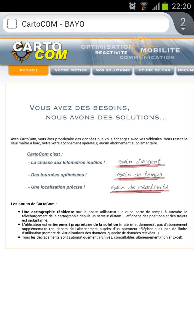
we have this at work.
the eye of moscow above.
which takes the position every 30sec and measures the speed.
when they return they analyze us. it's forbidden. but that hierarchy ...
if between 2 points 3 hours ago: where you are. what are you doing ... you disconnected the device. you signed you have no right.
What ... sign what !!!
soft is cartocom
Last edited by plasmanu the 03 / 07 / 12, 22: 25, 1 edited once.
0 x
"Not to see Evil, not to hear Evil, not to speak Evil" 3 little monkeys Mizaru
-
Christophe
- Moderator
- posts: 79326
- Registration: 10/02/03, 14:06
- Location: Greenhouse planet
- x 11044
Christophe wrote:I don't know how the information is transmitted
A priori it's 3G beast:
FLYMASTER LIVE-TRACKING NAVIGATION SYSTEM (PATENT PENDING)
The GSM / GPRS module (Quad Band) of the Flymaster LIVE allows the connection to a remote server which provides live-tracking on GoogleEarth or other live tracking servers.
Other features will soon be available, for example:
- sharing of position and flight data with other pilots;
- automatic sending of messages in case of incidents;
- receipt of weather information, airspace, etc .;
- receipt of alarm or security warnings or information.
Only at 1000m above ground I don't know if the 3G network is still available ...
0 x
Do a image search or an text search - Netiquette of forum
-
Christophe
- Moderator
- posts: 79326
- Registration: 10/02/03, 14:06
- Location: Greenhouse planet
- x 11044
Uh the manufacturer of my vario specifies:
So my b) must finally be able to be done with Google Earth ...
Google Earth (Free)
This software will allow you to view your tracks in 3D and create waypoints for your VGP.
So my b) must finally be able to be done with Google Earth ...
0 x
Do a image search or an text search - Netiquette of forum
-
- Similar topics
- Replies
- views
- Last message
-
- 4 Replies
- 2943 views
-
Last message by toto65
View the latest post
09/03/08, 16:13A subject posted in the forum : The bistro: site life, leisure and relaxation, humor and conviviality and Classifieds
-
- 12 Replies
- 27118 views
-
Last message by Supertux
View the latest post
17/01/08, 07:58A subject posted in the forum : The bistro: site life, leisure and relaxation, humor and conviviality and Classifieds
-
- 1 Replies
- 3955 views
-
Last message by Christophe
View the latest post
23/07/03, 14:01A subject posted in the forum : The bistro: site life, leisure and relaxation, humor and conviviality and Classifieds
Go back to "The bistro: site life, leisure and relaxation, humor and conviviality and Classifieds"
Who is online ?
Users browsing this forum : gegyx and 388 guests